Thursday, 23 October 2014

Bird Henge Trail Stage No 7 Knook to the pedestrian bridge across the Wylye River


200 yards. Turn left at m for Knook crossroads  along a track which becomes a path.. Beyond the field on the right is a sewage farm for Knook Army Camp.This,then called Heytesbury Camp, was one of those opened in World War 1 in the Wylye Valley when huge numbers of soldiers were encamped in the Wylye Valley with quick rail connections to Southampton. The present buildings are all later.The camp has heavy use by British and NATO troops exercises on Salisbury Plain. You may hear explosions and see helicopters and Hercules planes. You will come to a bridge across the Wylye River on the left. This is a well known trout stream, carefully managed to maintain the stock.


In the corrugated iron shed  by the bridge  there is still machinery (see below) for pumping  water. A company called Dutch n Warminster provided much of the machinery for the local schemes which led to the false  notion that the Dutch were involved - admittedly their specialty.

 
The sluice created a pool which was used for swimming until the 1950's . The photos below show a similar pool near Crockerton further up the Wylye with bathers before World War.


The remains of the sluice remained as a precarious plank across the river until the 1970's like this one further down stream in 2015 which in that year was replaced by a new sluice.


The water meadows were flooded deliberately in the early spring to make the grass grow for the sheep. The view across the water meadows  would have looked something like this but this was natural flooding in January 2014 after months of heavy rain created ore or less a continuous lake in                                             the meadows to Salisbury and beyond


Just beyond the bridge you will see the remains of a sluice that was used to control the water supply to the meadows. Nowadays it is usually  dry. This image was taken as the one above in January 2014 From the bridge continue along the path above the river. Continue along the path above the river.


Bird Henge Trail No 8 Bridge to Bird Henge


440 yards Continue along path beside and above the river on north side.Along the path are remnants of iron fencing installed in 1789 when the  land in Heytesbury and Knook was enclosed. The land had been common with a complicated patchwork of individual rights. The map below  was drawn up in 1774 showing the enclosed and common land.- a patchwork of tiny strips. Enclosure and rationalization was  hugely involved. In 1783 an Act of Parliament to enclose the land of Heytesbury refers to "the said open and common fields, downs common meadows lie intermixed and dispersed and inconveniently situated with respect to the houses and inclosed lands of the owners and proprietors thereof." The commissioners in charge took solemn oaths to be impartial  Land had to be swapped in order that that those with rights ended up with something equivalent to what they had before. In the transition period the  commissioners laid down what should be planted  where and when so that on acquiring new land one would find the same crop as one had had previously.And    
                                         there had to be new paths such as this one.                      


The maps below show Heytesbury army camp in World War 1  which extended both sides of the A36 road with parts of it in what is now the property of Bunters, site of Bird Henge. The present camp      
                                     north of the A36 is now known as Knook Camp.


Bird Henge Trail Stage No 9 Bird Henge

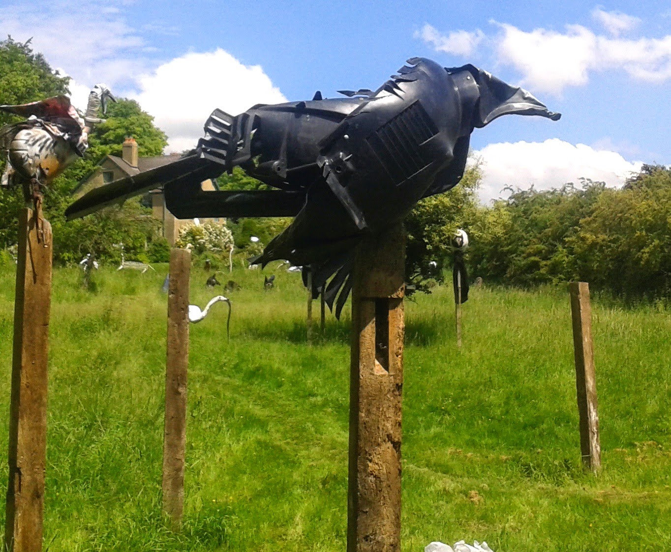
Bird  Henge was created  by the Scraptors Sculpture Group in 2014 and is close to a public path and visible from it at all times. It is located  at Bunters  belonging to Anthony Wilson one of the members.. He and his  fellow Scraptors Paul Boswell  and Rachel Macleay  specialize in themed sculpture trail making sculpture mainly with recycled materials. The Bird Henge and this accompanying Bird Henge Ramblers Trail received a grant from the Cranborne Chase and West Wiltshire Downs Area of Outstanding Natural Beauty. Bunters is on the edge of that area which stretches  south and east.The property is named not after the fat schoolboy but is an old place name; there was a small field here as long ago as  1774 called Bunter's Field.  Bird Henge contain Wiltshire birds and some imaginary mythical ones. A procession of high priests and humanoids with bird like heads processes  through the Henge. Below a Great Bustard which has been re-introduced on Salisbury Plain since 2004 in the Great Bustard Project. This is the world's heaviest flying bird. It was hunted to extinction in the 1840's  in this area, its last stronghold in  England.
                           
                        Below Scraptors Rachel and Paul at work on the Great Bustard


Below a Barn Owl.They have suffered from a lack nesting sites in rotten tree stumps and the like. A programme of installing artificial nests particularly on the huge Ministry of  Defence estate has helped their recovery in the although  some very long cold periods and a very wet winter has set that                                   back. A TV satellite dish provided the head for this owl.


Above a Lapwing or Peewit. The latter name recalls its plaintive cry that used to be common in the county when there were big flocks on ploughed fields.In October 1971 a flock of 11,000 was recorded near Tilshead  on Salisbury Plain..Nowadays it was a rare event when 390 were seen at Langford Lakes down the Valley. Changing farming methods have reduced their numbers. The head for the Lapwing has a kettle as a base and the body car wheel arches.


The Little Egret has spread recently  into the Wylye Valley via France.The first record of one in Wiltshire was in 1992,They are now permanent residents.They can be spotted near Bird Hernge.The body of the sculpture was the petrol tank of a Yamaha RD350  motorbike and was made for the Scraptors' sculpture trail at Stourhead, the National Trust property in Wiltshire in 2011 where it stood in one of the lakes (see below).


The Raven is now quite widespread again in Wiltshire and southern England; its population was once                                  confined to remote mountain areas  in Wales and remote seaside cliffs..

 
A mythical bird above and Below a Red Kite. They are common in Savernake Forest in the north of the county and can sometimes be seen locally. Their forked tales are their  give away distinctive feature.


Bird Henge is at Bunters, a  place  name going back to  the eighteenth century. It was occupied by  Heytesbury Camp in World War 1 which stretched both sides of the A36. The northern part remains as Knook Camp. The postcard below was customized with the names                                                  of camps all over the UK.


Below soldiers at Heytesbury Camp in World War 1

               
           Below a member of the Royal Field Artillery is visited by his parents at Heytesbury Camp                                                                               in World War1

T


Below an officer of the Royal Field Artillery at Heytesbury Camp in World War 1

               
                         Below a military band marches in Heytesbury in World War 1

Australasian soldiers, Aussies and Kiwis, pose with weapons of war in Heytesbury Camp in 1915.
Note horses in background.


   ####Below scenes of life at Bunters in the 1930's.


Below two postcards sent by soldiers in World War 1 to friends and relations


Bird HengeTrail Stage No 10 to Park Lane Heytesbury

460 yards. From Bird Henge continue along path leaving a wood of fir trees on right. After 220 yards you will come to some steps which lead down to a path to the left starting alongside the A36. Continue towards the bollards.  On the left is  a milestone erected in 1840 when a Turnpike Act consolidated roads leading from Warminster..The decaying tarmac was the A36 until the bypass was built.  You will come to Park Lane going left and Park Street going straight ahead. A diversion of 100 yards along Park Street will bring you to these gates. 


Rather strange to have these grand early nineteenth century gates leading to a modern garage.They were the gates that led through the park  to Heytesbury House. The coat of arms are those of the Barons Heytesbury. William Ashe  a Court was made a Baron on becoming British Ambassador to Saint Petersburg in 1828. In 1883 the  Lord Heytesbury of the day had 7025 acres in Wiltshire, 4805 in the Isle of Wight and 13303 in County Wicklow. Nearly all  Heytesbury belonged to Heytesbury. In World War 1 the House was requisitioned for use by army officers, among them Dennis Wheatley, the thriller writer whose mess bill at Heytesbury House survives in the Imperial War Museum.
Siegfried Sassoon, the war poet,  bought the house and park in 1933 and lived there until his death in 1967. He entertained well known friends such as Lawrence of Arabia. The new bypass divided the park in 1986. The Department of Transport paid for the gates below to be moved to the new drive north of the A36  to the house,then owned by George Sassoon , Siegfried's son. In 1993 West Wiltshire District Council  insisted on their return to the original site and, after threatened fines, got their way. The present house behind and to the right of these gates replaced  a much smaller lodge.


In the 1920's the Heytesbury estate was selling up most of its land.The notice below announced the sale of "about 55 cottages."

                                     
                                          Return to Park Lane and continue along it.

Bird Henge Trail Stage No 11 Park Lane to Heytesbury Mill


490 yards. Park Lane leads straight to Heytesbury Mill. On left you will see first  this building known as Everett's Yard  until recently renamed after upgrading.  It is marked in a map of 1832 as a Factory.This wan not a manufactory  where things were made but a factory in the older sense of a warehouse. It most likely stored textile work produced by home workers. The Everett family prospered by providing generations of stewards for the Heytesbury estate. They became successful textile manufacturers and ascended into the ranks of the landed gentry. They over reached themselves by paying for a very expensive new church with a spire built between  1866 and 1868
by a very expensive architect, John Loughborough Pearson,  in the neighbouring  Sutton Veny.

On the right of the lane is a  winter bourne usually dry even in winter. In February 2014 it lived up to                                         its name.living up to its name.

Above nineteenth century cottages with cob walls that is to say made of mud and straw.


         The house above was recently made by converting a one storey farm building.


Above Mill Farm, a farm until recently. It was a woolen mill in the 19th  century then a corn mill. After this corner turn left  along the track at the end of the cottages on the left


Bird Henge Trail Stage No12 Heytesbury Mill to Knook


780 yards  There is a patch in this stage which can be very muddy and after very heavy rain almost impassable.You may prefer, after seeing the first two items shown here below and above, to return to Knook the way you came and resume the walk at Stage 13.   Turn left down a track just after the cottages. ( You will see a plaque with No 131  on the wall ). Ahead of you to the left you will see the remains of an old sluice gate which still had, when this photo  above was taken, a rotten bit of wood at the top. These remains give an idea of the scale and sophistication of the irrigation scheme in place to flood the water meadows . The flat fields you now see were then more like a Dutch landscape with ditches. Nearby is a pile of masonry (see the image below) This may have been dumped by an errant lorry driver from miles away but they usually choose more remote locations for that.This is more likely to be some relic of the waterworks dumped in the nearest convenient spot.The curve suggests it being designed to take water.The importance of the irrigation of the meadows is reflected in a clause in a lease in 1821 from the landowner Sir William A Court to Mr William Flower for the mill that Sir William kept control of the hatches for drowning the meadows.


Turn right and then after a few yards go through a metal gate into the open field. At this point if there has been heavy rain it may be advisable to return as suggested above. If you continue with stage 12 as s you walk through the field you will get a good view of  Garstons below  in origin a fishing lodge for the summer built in a Tudor style. It was built on land with fishing rights on land bought from the Heytesbury Estate which sold a lot of land in the 1920's. Garstons is an old place name - Garston's Field appears on a map of 1774.. The house has perhaps a unique distinction of two connections with the Titanic through two separate families who have lived there. They both had relations on the doomed liner.  She  survived and he drowned.


The next image of trees is a spot,some 320 yards from the gate,     where you may be able if the vegetation is not too long to spot some masonry surviving from the irrigation scheme.


    Below are some substantial remains of the irrigation scheme a little further along.


Turn diagonally left at the next field aiming for the metal gate in the far left corner. You will arrive back at the River Wylye, Turn left for 20 yards to look at this concrete bridge (below)  which is survivor of one thrown across the Wylye by Allied troops preparing for D-day in 1944. They used what came to hand including it seems, old railway tracks probably left over from the temporary railways built in World War to service the army camps in the valley.There were two more similar bridges further down the Wylye one of  which has been replaced recently and the other removed. Beer barrels filled with concrete were used in one of them.


There are now two cottages here where there were once four by the river  in 1887 as shown on a map of that date.. The other two  were to the left of this - a reminder that the countryside has known periods of depopulation. Below the large and wide block of masonry under the bridge suggests that there may have been a sluice here once.An old photo suggests that the river immediately downstream had higher banks in the early twentieth century which would fit this hypothesis.  Cross the bridge Walk though Knook and turn right back towards Upton Lovell.

#.